
Estimated reading time: 7 minutes
Discover the best apps for hiking in 2024! These mobile apps are perfect for outdoor adventures and offer essential features to enhance your hiking experience. I swear by a few mobile apps when hitting the trail. Here are my picks for the best mobile apps for hiking.
The 7 Best Mobile Apps For Hiking in 2024
1. AllTrails
AllTrails is a popular mobile application and website designed for outdoor enthusiasts, particularly hikers, trail runners, and mountain bikers. It provides a platform for users to discover, plan, and share information about trails and outdoor activities.

My favorite part about AllTrails is that you can download the trail before you go. If you get lost or off-trail, you can pull it up even when you have no service. This app has saved me so many times during my hikes.
AllTrails is my favorite hiking app and my number one pick for the best mobile apps for hiking.
Website: All Trails
2. Gaia GPS
Gaia GPS is an excellent hiking companion due to its comprehensive features that are tailored to outdoor enthusiasts. With detailed topographic maps, reliable GPS navigation, and extensive trail coverage, Gaia GPS helps hikers plan routes, track progress, and confidently explore the backcountry.

The app’s offline map capabilities ensure accessibility even in remote areas with limited cellular service. In contrast, its customizable map layers allow users to tailor their maps to specific preferences and needs. Additionally, Gaia GPS offers advanced features such as route planning, waypoint marking, and real-time tracking, making it an indispensable tool for hikers seeking reliable navigation and exploration assistance on the trails.
Website: Gaia GPS
3. CAIC (Colorado Avalanche Information Center)
This app is a vital resource for winter hikers visiting Colorado. It offers avalanche forecasts, safety tips, and customizable alerts. Users can access avalanche danger levels, recent incident reports, educational resources, and interactive maps to plan routes and assess hazards.

Developed by the Colorado Avalanche Information Center, the app helps backcountry travelers stay safe and informed while enjoying winter activities in avalanche terrain.
CAIC is one of the best mobile apps for hiking in Colorado.
Website: CAIC
4. Hiking Project
Developed by REI, Hiking Project features a comprehensive collection of hiking trails with detailed trail maps, elevation profiles, and user reviews. It covers trails across the United States and allows users to track their hikes and contribute to the community.

The app’s intuitive interface allows users to search for trails based on location, difficulty level, and length while providing essential information such as elevation gain, trail conditions, and points of interest along the route.
Hiking Project also offers offline map access, allowing hikers to explore remote areas without relying on cellular data. Whether you’re a beginner or an experienced hiker, Hiking Project is a valuable resource for planning and enjoying your next outdoor excursion.
Website: Hiking Project
5. Komoot
Komoot is a versatile app for outdoor enthusiasts. It offers personalized route planning for hiking, biking, and various other activities. With its detailed maps, turn-by-turn navigation, and highlights of points of interest along the route, Komoot ensures an enjoyable outdoor experience.

What sets Komoot apart is its ability to tailor routes based on users’ fitness levels and terrain preferences, providing customized recommendations that suit individual needs and preferences. Whether you’re embarking on a challenging hike or a leisurely bike ride, Komoot empowers users to explore confidently and discover new adventures in the great outdoors.
Website: Komoot
6. Outdooractive
Outdooractive, formerly known as ViewRanger, offers detailed topographic maps, which are reliable companions for outdoor enthusiasts. It also provides GPS navigation and offline map access.

While other apps may offer similar features, Outdooractive can help you discover unique outdoor experiences, reliable route suggestions, and the best maps worldwide — as recommended by thousands of mountain guides, trail wardens, and other industry pros.
Website: Outdooractive
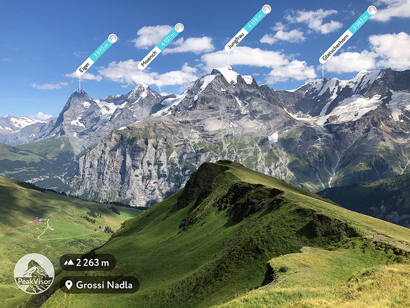
7. PeakVisor
PeakVisor provides users with even more tools to enhance their hiking experience. The app utilizes augmented reality technology to identify mountains and peaks in the surrounding landscape, allowing hikers to quickly recognize and learn about the peaks they encounter on their adventures.

In addition to offering detailed information about each peak, including elevation, prominence, and distance from the user’s location, PeakVisor also provides panoramic views from the summit of each peak, giving users a virtual glimpse of the breathtaking vistas that await them.
With its immersive features and informative content, PeakVisor enriches the hiking experience and inspires users to explore and discover the natural wonders of the world around them.
PeakVisor is one of the best mobile apps for hiking because you get to explore new peaks around you!
Website: PeakVisor
Best Hiking Trails
There are so many unique places to hike all over the United States and worldwide where you can test your Hiking Apps. While I can’t cover all of my top picks, here are a few of my favorites.
If you are visiting Colorado, read my guide on The 5 Best Wildflower Hikes In Colorful Colorado or read A Winter Hiking Guide To Mount Sniktau: One Of Colorado’s 13ers.
Are you visiting Maine? Hike to Acadia National Park’s Fire Tower on Beech Mountain, or Hike The Bar Island Trail At Low Tide In Acadia.
Hike Around Oregon’s Most Beautiful Waterfall, Multnomah Falls, for massive waterfall views.
Want to admire the most beautiful lake that I have ever hiked to? Then, read about Glacier National Park’s Enchanting Avalanche Lake Hike.
You can even Hike the Thurston Lava Tube at Hawaii Volcanoes National Park!
Click the pic below for all of my hiking guides by location.

Where Do You Want To Travel Next?